The PCH Project

Goiás, Brazil

Actual Picture of the PCH Project

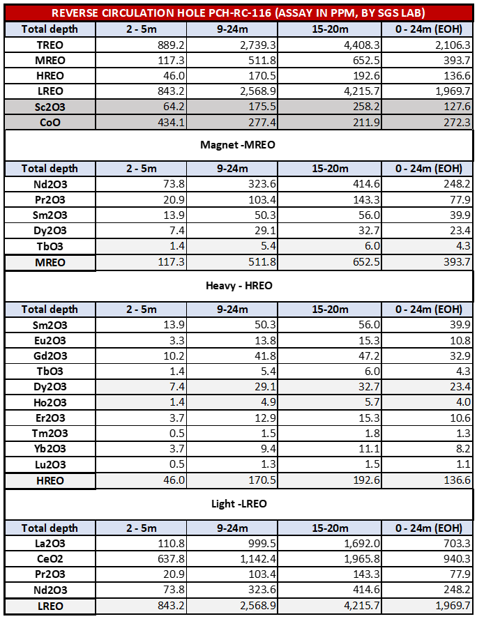
Maiden Mineral Resource Estimate

The Mineral Resource Estimate (MRE) for the project has been scheduled with an effective date of February 1, 2024. It is authored by Mr. Yann Camus, P.Eng., a professional engineer employed by SGS, and adheres to the current Standards on Mineral Resources and Reserves, Definitions, and Guidelines set by the Canadian Institute of Mining, Metallurgy and Petroleum (CIM). The report clarifies that Mineral Resources which are not classified as Mineral Reserves do not currently show economic viability, and emphasizes that further exploration and additional drilling will be necessary to upgrade Inferred and Indicated Mineral Resources to Measured Mineral Resources. It also notes the inherent uncertainty in converting any part of Mineral Resources into Reserves.

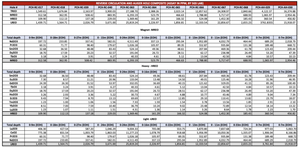
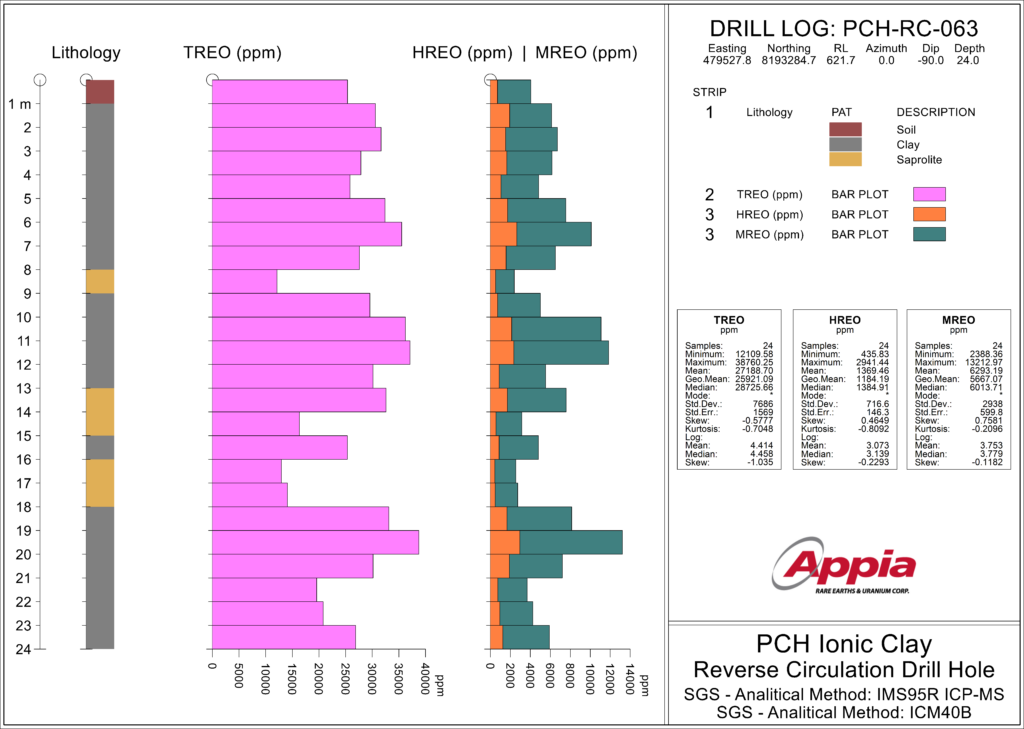
The analytical processes used for the MRE were conducted by SGS GEOSOL using methods such as ICM40B, which involves Multi Acid Digestion combined with ICP OES and ICP MS, and IMS95R, which uses Lithium Metaborate Fusion followed by ICP-MS. The MRE is defined with a cut-off Net Smelter Return (NSR) value of $10 per tonne. Details on the full price list and recovery methods used for NSR estimation are included in Table 2, which also lists an estimated basket price for Total Rare Earth Oxides (TREO) at $26.98.

For optimizing the mining operation, GEOVIA’s WhittleTM software was utilized to outline an optimal pit envelope, indicating reasonable prospects for economic extraction. The preliminary pit optimization includes parameters such as a 30-degree overall pit slope, mining costs of $2.10 per tonne, processing and general/administrative costs of $9 per tonne, and accounts for a total mining loss and dilution of 5%. Further specifics of these parameters are also provided in Table 2, where forward-looking prices for the basket and oxides are based on market trends and economic forecasts, although actual prices may vary due to changes in these factors.

The report also addresses the calculation of bulk densities, which were determined through physical test work and assumptions about porosities for each type of material. Definitions for categories of oxides like Total Rare Earth Oxides (TREO), Magnetic Rare Earth Oxides (MREO), and Heavy Rare Earth Oxides (HREO) are detailed, listing the specific oxides included in each category. Finally, the report warns that the MRE might be significantly impacted by various external factors including environmental, permitting, legal, title, taxation, socio-political, marketing, or other relevant issues, emphasizing the complex nature of resource estimation.

Current Work

The PCH Ionic Clay Project is located in Goiás state, Brazil, approximately 216 km by GO-060 from Goiânia, the state capital, and 410 km from Brasilia, the capital of Brazil. The property is located approximately 30 km from Iporá, a mid-size city of approximately 31,500 population (2018 census). Access to the property from Iporá is excellent by regional roads, with a mix of hard surface and gravel surface roads. Within the property boundaries, a network of gravel surface rural and unsurfaced farm roads provides excellent access. Figure 1 illustrates the property location.

The PCH property surrounds tenements held by Vale and Dundee Precious Metals in the central area of the tenement package, as well as tenements held by Atlas Litio in the northwest of the overall PCH tenement holdings (Figure 2). The Vale and Dundee tenements are associated with a significant ultramafic complex comprised of dunite and peridotite which is the focus of nickel exploration.

DNPM Process Number

Area (ha)

860060/2018

1901.19

860058/2018

1874.60

860059/2018

1864.41

860498/2020

1990.87

860466/2020

1005.85

860464/2020

983.40

860465/2020

1978.45

860469/2020

1995.29

860468/2020

1972.94

860467/2020

1984.03

860307/2023

1982.69

860343/2023

1647.94

860342/2023

1965.26

860341/2023

1982.23

860340/2023

1969.31

860339/2023

1982.73

860337/2023

1983.87

860338/2023

1964.39

860336/2023

1984.98

860335/2023

1980.50

860334/2023

1983.50

860333/2023

1984.98

Total

40,963.41

Source: 3S LTDA

Figure 1 - Location of current and recently staked claims and associated Thorium readings

Figure 1 provides a detailed tenement map, including the recently acquired tenements. All tenements are held as exploration tenements and are valid for various periods from June 15, 2024 through to at least 30 September 2027. Surface rights are held by local landowners. The surface area is currently predominately farmland used for grazing and field crops such as soybeans.

Exploration to date on the property has identified six priority targets (“alvo”) on portions of the tenements in the western half of the property (Figure 3). Target IV has been the primary focus of activity to date.

Access to the property is excellent via a network of hard surface, gravel and unsurfaced roads from Iporá and throughout the tenements. The climate is predominantly tropical, hot, and semi-humid with a dry season (April to September) and a rainy season (October to March). The average annual rainfall is 1,500 mm. The average annual temperature varies between a maximum of approximately 33°C in the summer and a minimum of 17°C in the winter. The project area is located within a low

To medium rainfall area. There is no surface water in the area except for small creeks. The vegetation in the area is represented by fields, savannas and gallery forests. The area is classified as “cerado”, characterized by the occurrence of grasses, shrubs and spaced trees. Much of the original vegetation has been replaced by pastures with intense livestock activity and field crops such as soybeans. Higher elevations are typically moderately forested. Local roads are well maintained and travel by standard vehicles is generally possible. 4WD vehicles are generally not required.

Figure 2 - Location of current and recently staked claims and associated Thorium readings

Figure 2 provides a detailed tenement map, including the recently acquired tenements. All tenements are held as exploration tenements and are valid for various periods from June 15, 2024 through to at least 30 September 2027. Surface rights are held by local landowners. The surface area is currently predominately farmland used for grazing and field crops such as soybeans.

Figure 3: Tenements and Exploration Targets, PCH Project (as of April 2023)

Iporá is a regional population centre with a population of approximately 31,500 (2018 census). The city can provide a full range of services in support of exploration. There is a municipal airport which can handle small regional carrier aircraft. The nearest railway siding is at Goiânia. The railway leads north to the town of Palmas and south the São Paulo and the port of Santos.

Current Work

Target IV

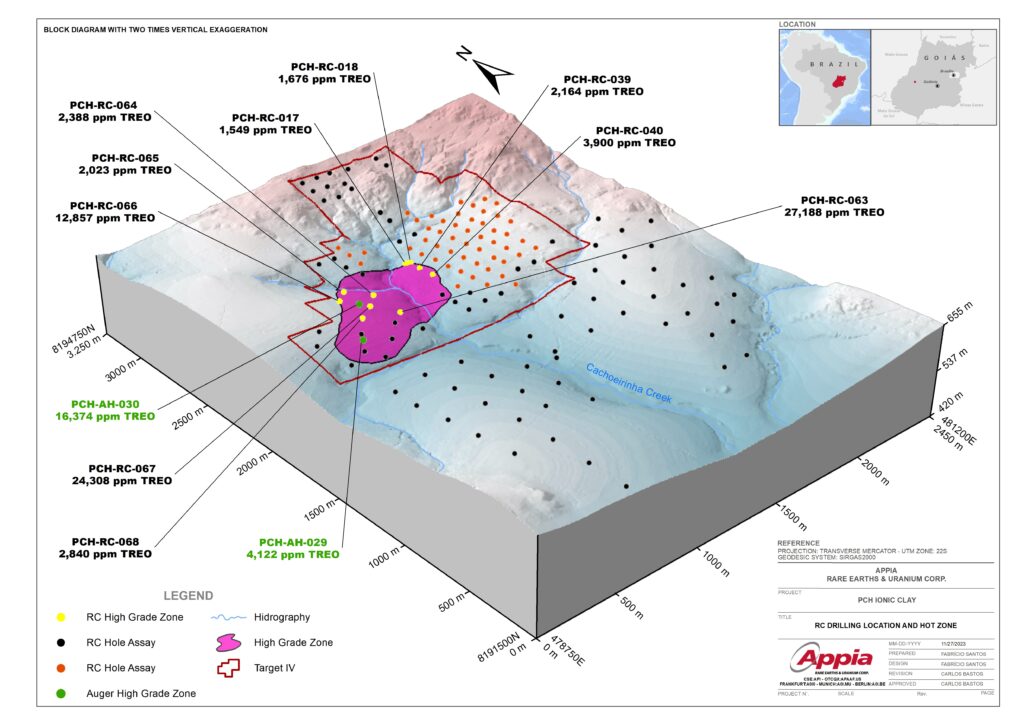
Ongoing expansive auger drilling, reverse circulation (RC), and diamond drilling campaigns in and around Target IV, concurrent with ground geophysics, systematic geological mapping, LiDAR surveys, ortho photo surveys, and sampling.

Buriti Zone

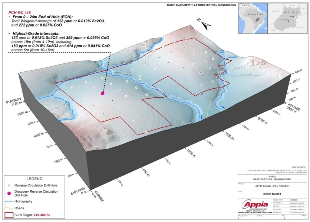
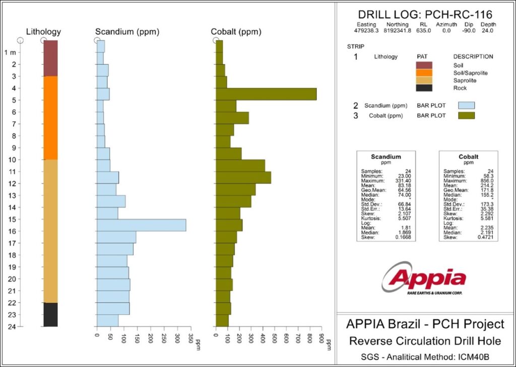
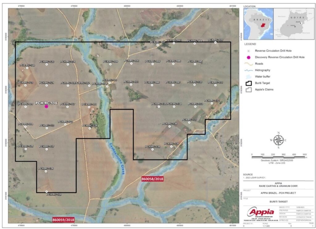
This newly identified mineralized Buriti Target, located within the weathered profile southward from the current area of interest, was revealed through exploratory RC and Auger drilling conducted as part of the completed 2023 drill program.

Sampling Process at PCH

In this video, we show Appia’s building where field samples are gathered and prepared for shipment to SGS geological services

Historical Reports

As of now, there are no official technical or mineral reports accessible for the PCH project.

Historic Work

TBA

Gallery

Subscribe

We have an app!

The Appia Rare Earths  & Uranium app provides the company stock price, news release notifications, corporate bios, project updates, project images, video interviews, and contact information.

Scan the QR code to click the button below to download it now!